Are you looking to unlock powerful insights for your research? Public GIS data can be your secret weapon.
It’s a rich source of information that’s easy to access and packed with valuable details about geography, demographics, environment, and more. But how do you make sense of it all and use it effectively? This guide will show you step-by-step how to tap into public GIS data, so you can boost your research with real-world, accurate information.
Keep reading to discover simple tips and tools that will transform your approach and give you a clear edge.
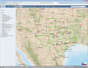
Credit: www.rrc.texas.gov
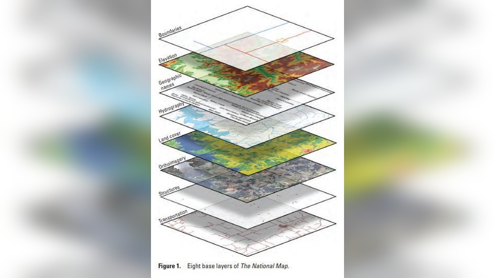
Sources Of Public Gis Data
Public GIS data comes from many sources. These sources provide valuable information for research. Finding the right data helps create accurate maps and analyses. This section covers key places to find public GIS data. Each source offers different types of data and tools.
Government Portals
Government portals host vast GIS datasets. These sites offer free access to maps and spatial data. Examples include national, state, and local government websites. Common data types include land use, transportation, and environmental information. Data here is usually reliable and updated regularly. These portals support public projects and research needs.
Open Data Platforms
Open data platforms share GIS information freely with the public. They often gather data from multiple sources. Users can download datasets in various formats. Some platforms allow users to view data online with interactive maps. These platforms encourage data sharing and transparency. They serve researchers, planners, and developers.
Academic And Nonprofit Resources
Universities and nonprofit organizations provide specialized GIS data. These sources focus on topics like ecology, urban planning, and health. Data from these groups may come from field studies or surveys. They often share data to support education and community projects. These resources add unique insights not always found in government data.
Types Of Gis Data Available
GIS data comes in many forms. Each type serves a different purpose in research. Knowing the types helps you choose the right data for your project.
Satellite Imagery
Satellite imagery shows pictures of Earth from space. These images capture land, water, and clouds. Researchers use them to study weather, land use, and changes over time. Public sources offer free satellite images with good detail.
Topographic Maps
Topographic maps display land features like hills, rivers, and roads. They use contour lines to show elevation and shape. These maps help in planning, hiking, and environmental studies. Many public databases provide easy access to topographic data.
Demographic Data
Demographic data includes information about people. It covers population size, age, income, and more. Researchers use this data to analyze social trends and plan services. Governments often share demographic data openly for public use.
Environmental Data
Environmental data tracks natural elements such as air quality, water quality, and wildlife. This data helps monitor pollution and conservation efforts. Public agencies provide reliable environmental datasets for free research.
Accessing And Downloading Gis Data
Accessing and downloading public GIS data is the first step for any research project. Many government and private websites offer free GIS data. This data can help with mapping, analysis, and decision-making. Understanding how to find and download the right files saves time and effort.
Different sources provide data in several formats. Knowing these formats helps you choose the correct one for your software. Some sites also offer APIs or services for direct data access. Bulk downloading options can speed up the process if you need large datasets.
Data Formats And Compatibility
GIS data comes in many formats like Shapefile, GeoJSON, KML, and TIFF. Shapefiles are common for vector data. GeoJSON works well with web maps. KML suits Google Earth users. TIFF is popular for raster images. Check if your software supports the format before downloading. Some programs need conversion tools to open certain files.
Apis And Data Services
APIs let you access GIS data directly from a server. You can use them to get real-time or updated information. Many public agencies provide REST or WFS services. These allow querying and downloading specific data parts. APIs require some technical knowledge but offer flexible data access. Data services often support standard formats like GeoJSON or XML.
Bulk Download Tips
Bulk downloading saves time when working with large datasets. Look for download options labeled as “bulk” or “zip archives.” Some sites offer data by region or theme, making selection easier. Use download managers to handle large files smoothly. Check file sizes and storage space before starting. Break downloads into smaller parts if possible to avoid errors.
Preparing Gis Data For Analysis
Preparing GIS data for analysis is a crucial step in research. Clean, accurate data ensures better results. Without proper preparation, your analysis can lead to errors and wrong conclusions. This section explains key steps to prepare GIS data effectively.
Data Cleaning And Validation
Start by checking data for errors and missing values. Remove duplicates and correct wrong entries. Validate data against reliable sources to ensure accuracy. Clean data helps avoid mistakes during analysis. It also improves the quality of your research findings.
Coordinate Systems And Projections
GIS data comes in various coordinate systems. Use the correct system for your region or project. Convert all data layers to the same projection. This alignment prevents spatial errors and mismatches. Consistent coordinate systems make your maps accurate and easy to interpret.
Data Integration Techniques
Combine data from multiple sources to enrich your analysis. Use methods like spatial joins or overlay to link datasets. Ensure data formats are compatible before merging. Proper integration creates a comprehensive dataset. This helps reveal patterns and insights that single sources cannot show.
Tools For Working With Gis Data
Working with public GIS data requires the right tools. These tools help you view, analyze, and interpret geographic information. Choosing the right software can make your research easier and more effective. Several options exist, from free software to paid platforms and online tools. Each has unique features suitable for different needs.
Open Source Software
Open source GIS software is free to use. It offers powerful tools for mapping and data analysis. QGIS is a popular choice. It supports many data formats and has many plugins. Users can customize it to fit their projects. Open source tools are great for students and researchers with limited budgets.
Commercial Gis Platforms
Commercial GIS platforms provide advanced features and professional support. ArcGIS by Esri is a leading example. It offers tools for complex spatial analysis and data management. These platforms often include training and customer service. Businesses and organizations use them for high-quality results. They are suitable for large projects with detailed needs.
Web-based Gis Tools
Web-based GIS tools work directly in your browser. No installation is needed. Tools like Google Earth and ArcGIS Online allow quick access to maps and spatial data. They are user-friendly and easy to share with others. These tools suit users who want fast results without complex software.
Credit: sph.umd.edu
Analyzing Gis Data For Research
Analyzing GIS data is a key step in research using public geographic information. It helps uncover patterns, trends, and relationships within spatial data. Researchers use various methods to make sense of this information. These methods range from mapping to complex calculations. Each approach adds a different layer of insight to the research.
Spatial Analysis Methods
Spatial analysis involves examining the locations of features and their relationships. Techniques include buffering, overlay, and proximity analysis. Buffering creates zones around map features to study nearby areas. Overlay combines multiple layers to find common or differing features. Proximity analysis measures distances between points, lines, or areas. These methods reveal spatial patterns that are not obvious at first glance.
Visualization Techniques
Visualization turns raw GIS data into easy-to-understand maps and charts. Heat maps show concentration of events or features. Choropleth maps use colors to represent data values across regions. 3D models provide a view of terrain and structures in three dimensions. Visual tools help researchers spot trends and communicate findings clearly. Good visuals make complex data accessible to all audiences.
Statistical Approaches
Statistical methods analyze GIS data to identify significant trends and relationships. Spatial statistics measure clustering or dispersion of points. Regression analysis explores how variables influence each other over space. Hot spot analysis detects areas with high or low values compared to surroundings. These tools provide evidence to support research conclusions. Numbers and maps together strengthen the study’s reliability.
Ethical And Legal Considerations
Using public GIS data for research requires attention to ethics and law. Respecting rules protects people’s rights and avoids legal troubles. Understanding these points helps you use data responsibly. This section covers key ethical and legal considerations.
Data Privacy
GIS data can include personal information. Protecting privacy is important. Avoid sharing details that identify individuals. Use data that respects people’s confidentiality. Always check if data is anonymized before use.
Licensing And Usage Rights
Public GIS data often comes with licenses. These licenses explain how you can use the data. Some allow free use, others limit it. Read the license carefully before using the data. Follow the rules to avoid copyright issues.
Attribution Requirements
Giving credit is often required. Many data providers ask users to cite the source. Proper attribution shows respect and builds trust. Always include the right credits in your research. This helps maintain transparency and honesty.
Case Studies Using Public Gis Data
Public GIS data offers rich insights for many research fields. Researchers use this data to solve real problems. Case studies show how GIS data helps understand and improve communities.
Each project type uses GIS data differently. These examples highlight its power and flexibility. They help researchers see what is possible with public GIS data.
Urban Planning Projects
Urban planners use GIS data to map cities. They analyze land use, traffic, and population growth. This helps design better roads and public spaces. GIS data also shows where new buildings can fit. It supports decisions that make cities safer and cleaner.
Environmental Monitoring
GIS data tracks changes in forests, rivers, and air quality. Researchers watch for pollution and habitat loss. This data helps detect harmful trends early. It guides efforts to protect wildlife and natural resources. GIS maps make complex environmental data easy to understand.
Public Health Research
Health experts map disease outbreaks and health service access. GIS data reveals patterns in illness spread and risk factors. This supports better response plans and resource allocation. It shows where to focus health programs for greatest impact. GIS data links environment, lifestyle, and health for deep insights.
Tips For Maximizing Research Impact
Using public GIS data can greatly improve your research results. To get the best outcomes, follow some simple tips. These tips help you use the data more effectively and share your findings with others.
Start by combining different data sources. Work with experts to understand the data better. Finally, share your research clearly. These steps make your work stronger and more useful.
Combining Multiple Data Sources
Using more than one data source gives a full picture. Public GIS data can be mixed with census info, weather reports, or economic stats. This mix helps find new patterns and answers. Check each data set for accuracy and relevance. Keep data formats similar to avoid confusion.
Collaborating With Gis Experts
GIS experts know how to use data well. They help clean, analyze, and map data correctly. Teaming up with them saves time and reduces errors. Experts can suggest tools and methods you might not know. Their advice improves your research quality.
Publishing And Sharing Findings
Share your results in clear and simple ways. Use maps, charts, and short reports to explain findings. Publish on websites, blogs, or research platforms. Sharing helps others learn and build on your work. Open access increases the impact of your research.

Credit: www.giscloud.com
Frequently Asked Questions
What Is Public Gis Data Used For In Research?
Public GIS data helps researchers analyze geographic patterns. It supports studies in urban planning, environmental science, and social demographics. This data is freely accessible and enhances accuracy in spatial analysis for informed decision-making.
Where Can I Find Reliable Public Gis Datasets?
Reliable public GIS datasets are available on government portals, open data platforms, and university websites. Examples include USGS, NASA, and local government GIS servers. Always verify data currency and source credibility before use.
How Do I Properly Cite Public Gis Data Sources?
Cite public GIS data by including the dataset name, source, publication date, and URL. Follow citation styles like APA or MLA as required. Proper citation ensures credibility and respects data usage policies.
What Software Is Best For Analyzing Public Gis Data?
Popular GIS software includes QGIS, ArcGIS, and Google Earth Engine. QGIS is free and user-friendly, while ArcGIS offers advanced tools. Choose software based on your research needs and budget.
Conclusion
Public GIS data helps researchers find useful information quickly. It supports many types of studies and projects. Using this data saves time and money. Anyone can access and use these free resources. Explore different datasets to fit your research needs.
Practice with simple tools before trying complex analyses. Clear maps and data make your findings stronger. Keep learning to improve your GIS skills steadily. Public GIS data is a valuable tool for research success.