Have you ever looked at a GIS map and wondered what those numbers on parcels really mean? Understanding how to read parcel numbers can unlock a lot of valuable information about land ownership, property boundaries, and zoning.
If you want to make smarter decisions about real estate, planning, or even just satisfy your curiosity, learning to decode these numbers is a skill you can’t afford to miss. Keep reading, and you’ll discover simple steps to master parcel numbers on GIS maps, turning complex data into clear, useful knowledge for your needs.
Credit: www.berriencounty.org
What Parcel Numbers Represent
Parcel numbers are key identifiers used in GIS maps. They help locate and describe specific pieces of land. Each parcel number represents a unique property or land section. Understanding what these numbers mean is important for navigating GIS maps effectively.
Parcel Number Basics
Parcel numbers are codes assigned to land parcels by local governments. They serve as a land ID in property records. These numbers link to details like ownership, size, and land use. Every parcel has a distinct number to avoid confusion. They are essential for property management and legal purposes.
Common Parcel Number Formats
Parcel numbers can vary in style across regions. Some use simple numeric codes, while others include letters. Formats might show divisions like block, lot, and section. For example, a number can look like “123-45-678” or “A-12-34-56”. Knowing the format helps decode the parcel’s location and size.
Finding Parcel Numbers On Gis Maps
Finding parcel numbers on GIS maps helps identify land and property details quickly. These numbers are unique codes assigned to each land parcel. They play a key role in property management, tax assessment, and land use planning. Understanding how to find parcel numbers on GIS maps simplifies many tasks for homeowners, buyers, and professionals.
Accessing Gis Mapping Tools
Start by visiting your local government or county GIS website. Many offer free online mapping tools. These tools show detailed maps with parcel boundaries and numbers. Some sites require no login, making access easy. Use a desktop or mobile device for convenience.
Once on the site, look for the parcel map or property viewer. It often appears in the main menu or map gallery. Click the tool to open an interactive map. This map lets you zoom in and out to explore areas of interest.
Using Search Functions
Most GIS tools include a search bar for quick parcel lookup. Enter the owner’s name, address, or parcel number if known. The map will highlight the matching parcel automatically. This saves time and avoids confusion.
Some tools allow searches by legal descriptions or coordinates. Use simple keywords for best results. After the parcel appears, click on it to view detailed information. Parcel numbers usually show near the boundaries or in a popup box.
Breaking Down The Parcel Number
Parcel numbers on GIS maps may look like a string of random digits. Understanding these numbers helps identify exact land locations. Breaking down the parcel number reveals useful details about the property. Each part of the number has a specific meaning. Knowing these parts makes reading GIS maps easier.
Here is how to decode the parcel number step by step. Focus on the county or municipality codes first. Then, look at the block and lot identifiers. Finally, check for any extra number segments. Each section tells a different story about the parcel.
County Or Municipality Codes
The first part of a parcel number usually shows the county or municipality. This code tells which local area the property belongs to. It is often two to five digits long. These codes are unique to each county or city. This helps narrow down the parcel’s location quickly.
Block And Lot Identifiers
Next, the parcel number includes block and lot identifiers. The block number points to a specific section within the county. The lot number identifies the exact piece of land inside that block. These numbers help find the parcel on the map. They work like coordinates in a grid.
Additional Number Segments
Some parcel numbers have extra digits after the block and lot. These segments provide more details about the property. They can indicate subdivisions, buildings, or special land use. These numbers vary depending on the local GIS system. Understanding them offers a clearer view of the parcel’s features.
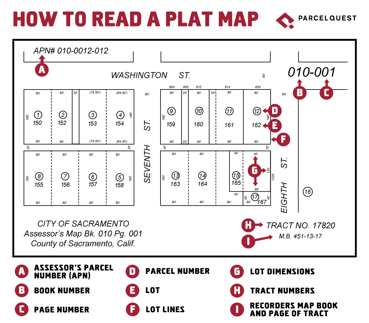
Credit: www.parcelquest.com
Interpreting Parcel Data
Reading parcel numbers on GIS maps helps you understand important land details. These numbers link to specific data about a piece of land. Interpreting this data gives insight into ownership, use, and taxes. This section breaks down key parts of parcel data for easy reading.
Land Ownership Details
Parcel numbers show who owns the land. The GIS map connects to records with owner names. You can see if the land belongs to a person, company, or government. This helps identify legal owners and any changes over time. Ownership details also reveal property boundaries and size.
Zoning And Land Use
Zoning codes describe how land can be used. These codes appear with parcel numbers on GIS maps. They show if land is for homes, businesses, farms, or other uses. Zoning rules protect neighborhoods and guide new building projects. Knowing zoning helps plan land development or purchases.
Tax Information
Tax data linked to parcel numbers shows property tax amounts. This includes current taxes due and past payments. Tax records also reveal any tax liens on the property. Checking tax info helps avoid surprises when buying land. It also shows if the owner pays taxes on time.
Common Challenges And Tips
Reading parcel numbers on GIS maps can be tricky. Different areas use various formats. Mistakes can lead to wrong property details. Knowing common challenges helps avoid errors. Simple tips make the process easier and faster.
Dealing With Different Formats
Parcel numbers vary by location and system. Some use long strings of numbers and letters. Others split numbers with dashes or spaces. Recognize the local format before starting. Compare with known examples to understand patterns. Practice reading different formats to gain confidence.
Verifying Parcel Information
Parcel numbers may not always match the map. Cross-check details like owner name or address. Use multiple sources to confirm accuracy. Errors in data entry are common in some maps. Double-checking prevents confusion and wasted time.
Using Official Resources
Official county or city websites provide reliable parcel data. They often have tools to search by parcel number or address. Use these sources to verify map information. Official records update regularly to stay accurate. Trust official resources over third-party sites for best results.
Credit: sonomacounty.gov
Frequently Asked Questions
What Is A Parcel Number On Gis Maps?
A parcel number is a unique identifier assigned to a land parcel. It helps locate and reference specific properties on GIS maps accurately.
How Do I Find Parcel Numbers On Gis Maps?
Parcel numbers are usually displayed within property boundaries. Use the map’s search or identify tools to locate parcel numbers easily.
Why Are Parcel Numbers Important In Gis Mapping?
Parcel numbers help in land ownership, taxation, and planning. They ensure precise property identification and data management on GIS platforms.
Can I Use Parcel Numbers To Get Property Details?
Yes, parcel numbers link to property records. They provide ownership, size, zoning, and tax information in GIS databases.
Conclusion
Reading parcel numbers on GIS maps helps you find property details fast. Each number tells a story about land size, ownership, and location. Knowing how to read these numbers makes navigating maps easier. You can check property boundaries or plan projects with confidence.
Practice often to become comfortable with the codes and patterns. Keep your focus on the numbers, and the maps will start to make sense. Understanding parcel numbers saves time and reduces errors in land-related tasks. Start small, and soon you’ll read any GIS map with ease.